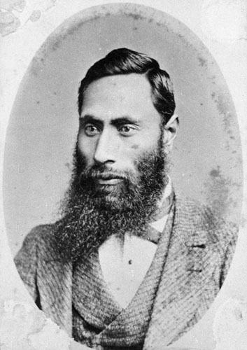
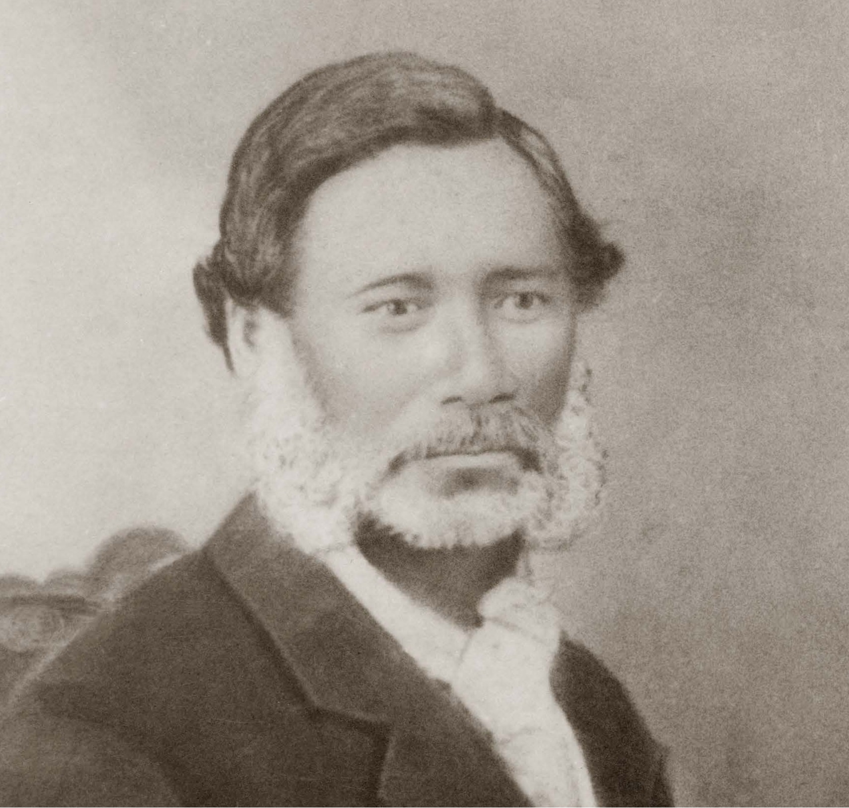
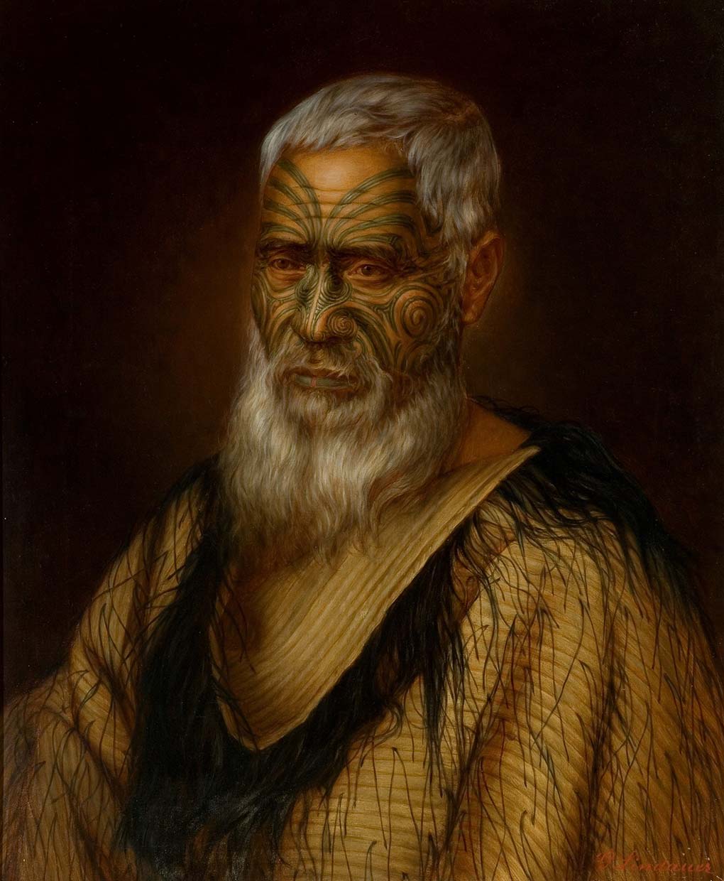
Ngāi Tahu – Cultural Mapping Project

Ngāi Tahu Mahinga Kai Map

Collected and collated by Hori Kerei Taiaroa 1880

This map shows the location of mahinga kai (food and resource gathering) sites, kāinga (villages), and kāinga nohoanga (campsites) in the Canterbury and Otago areas as recorded by Ngāi Tahu leader Hori Kerei Taiaroa from information provided by Ngāi Tahu kaumātua in 1880. The map and two accompanying notebooks known as the ‘mahinga kai lists’ are among the most important archives of tribal significance to Ngāi Tahu. Since their production, these documents have had a long and interesting life and passed through many hands. The map has been copied, traced, quoted, and referenced numerous times. A copy of the map and a translation of the lists were presented as evidence before the Waitangi Tribunal for the Ngāi Tahu Claim in 1987-1990. More recently, the documents have been integral to the creation of Kā Huru Manu.

Hori Kerei Taiaroa

Hori Kerei Taiaroa (Ngāi Tahu) was born at Ōtākou in the 1830s or early 1840s. His father was the Ngāi Tahu chief Te Matenga Taiaroa and his mother was Mawera of Ngāti Rangiwhakaputa. He married Tini Pana (Jane Burns) whose mother was of Ngāi Tūāhuriri. In accordance with his father's wishes, Taiaroa made the pursuit of Te Kerēme, his life's work. In 1875 he was granted a tribal mandate to lead this mahi on behalf of the iwi.

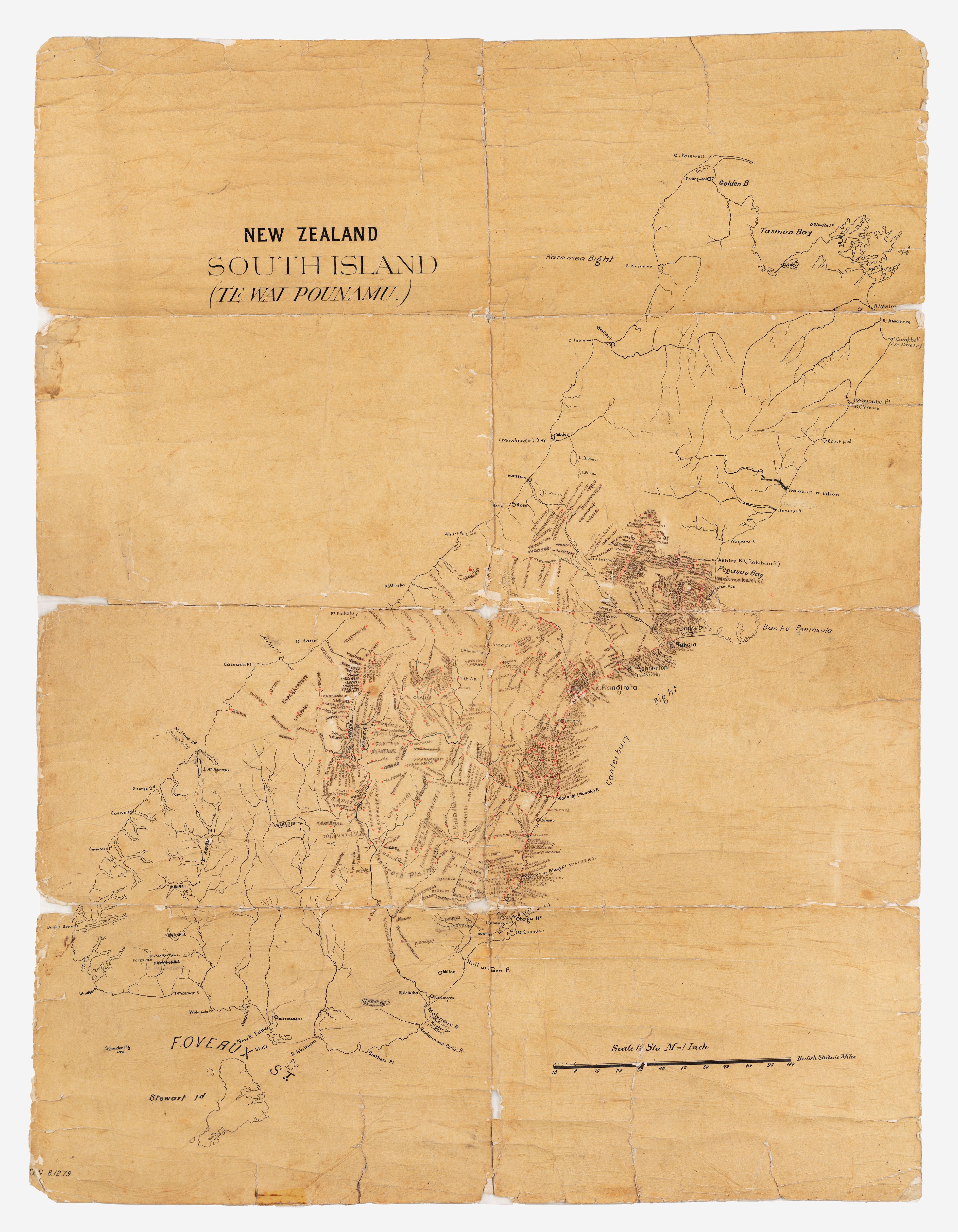
During his tenure as parliamentary representative for Southern Maori and on the Legislative Council he pushed for a series of inquiries into grievances arising from the Ngāi Tahu land purchases including the Smith-Nairn commission of inquiry which spurred the creation of the 1880 map. He was an outspoken critic of the government and vigorously advanced the Ngāi Tahu cause in Parliament in an often-lonely battle against impossible odds. He died at Wellington on 4 August 1905 and was buried in the churchyard at Ōtākou.
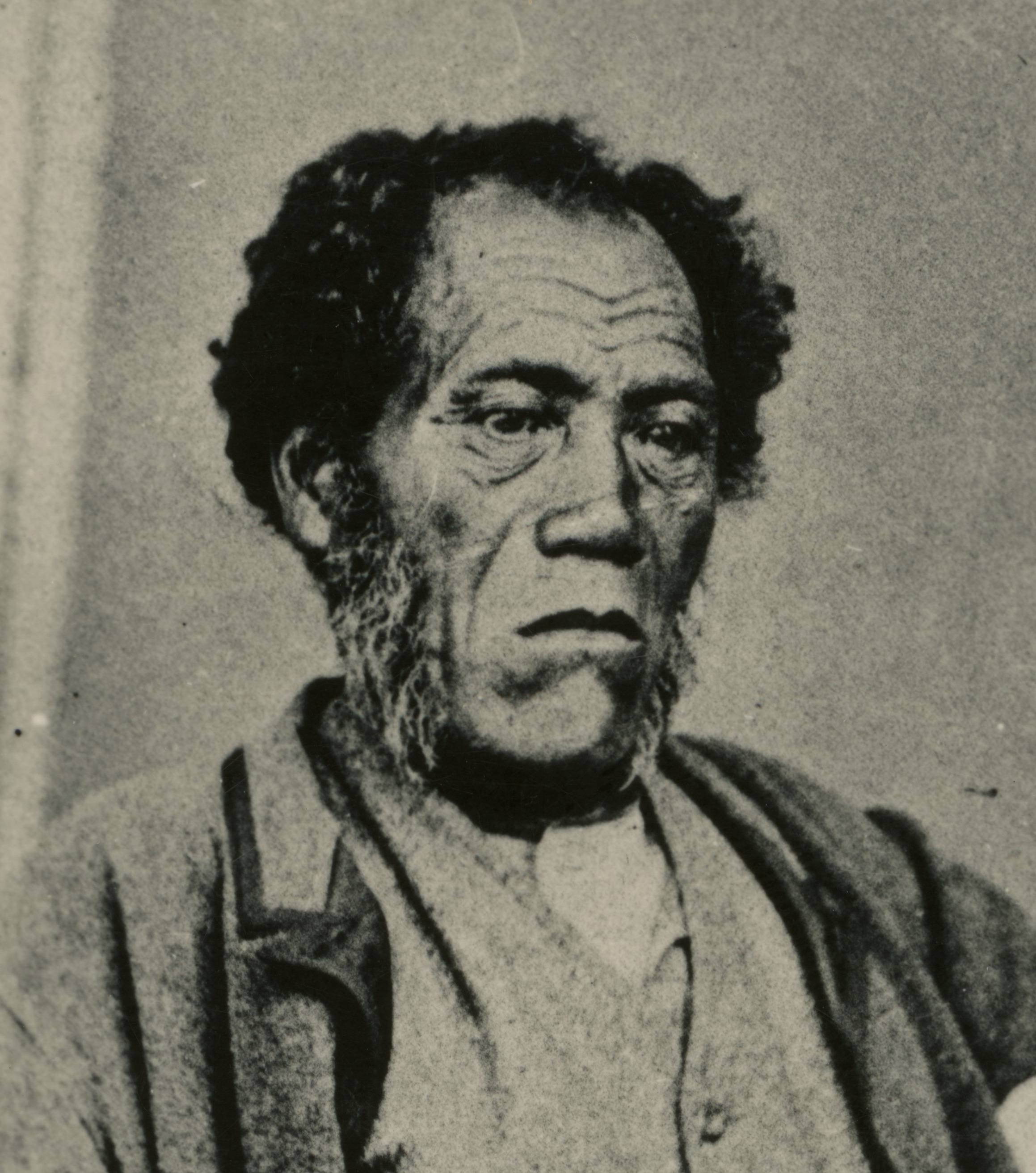
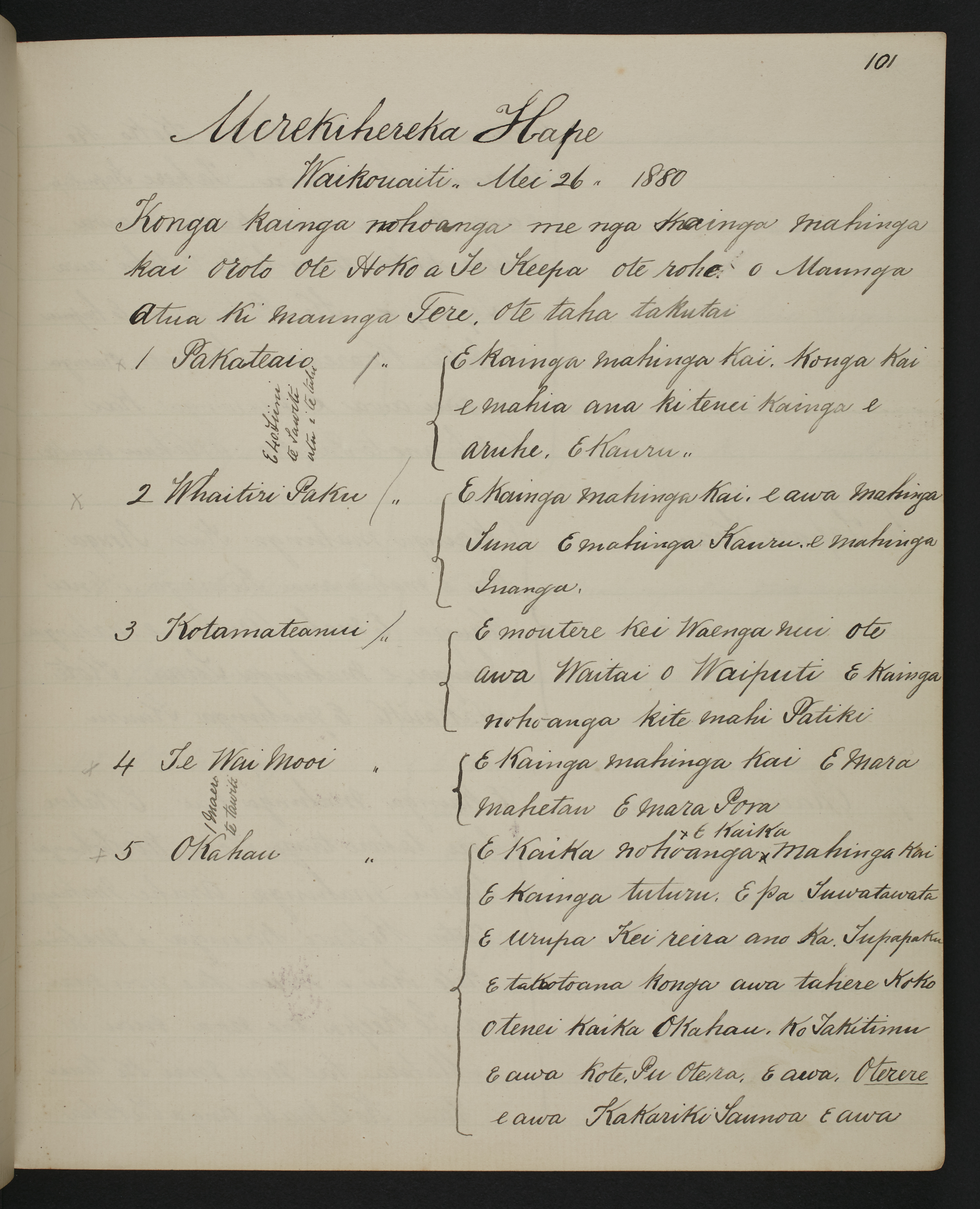
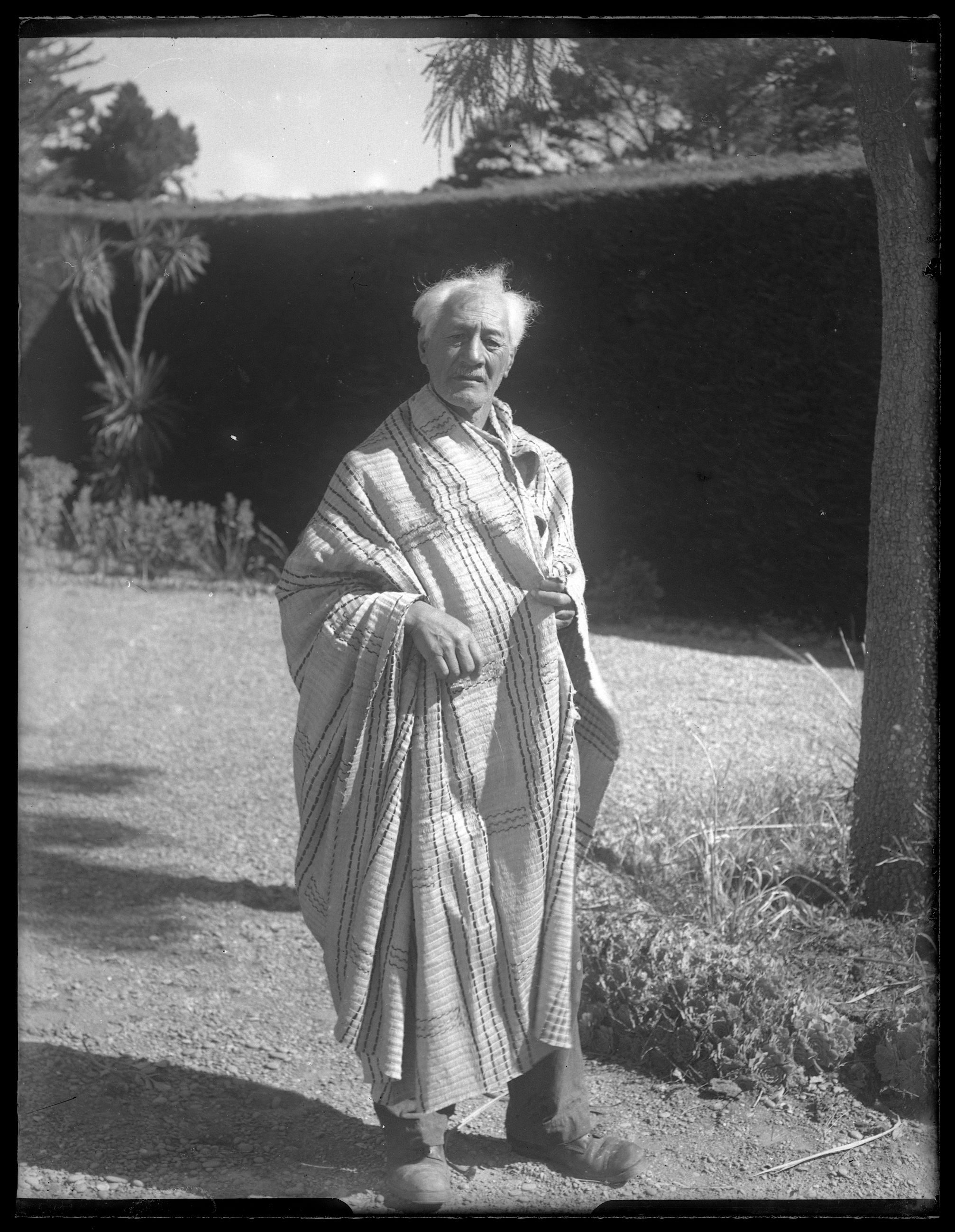
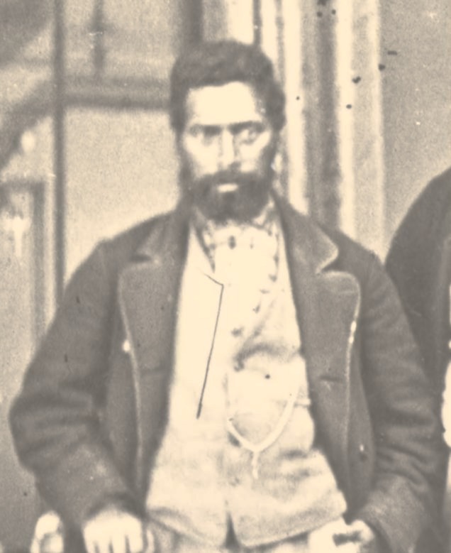
Hori Kerei Taiaroa, c.1903. Alexander Turnbull Library, 35mm-00149-e-F 

Smith-Nairn Commission 1879-1880

Through the advocacy of Taiaroa, and following two decades of protest by Ngāi Tahu, a Royal Commission of Inquiry (Middle Island Native Land Purchase Commission) was established in 1879 to investigate grievances associated with the Canterbury, Akaroa, Otago, and Murihiku land purchases. Thomas Smith (a private independent nominated by the Crown) and Francis Nairn (a retired judge of the Native Land Court nominated by Ngāi Tahu) were appointed to carry out the inquiry; thus it is commonly referred to as the Smith-Nairn Commission. Ngāi Tahu communities took a deep interest in the proceedings and had high hopes for a positive outcome.

Over twelve months from April 1879 to April 1880 a vast amount of evidence was collected and presented at hearings held in Auckland, Wellington, Ōtaki, Christchurch, Kaiapoi, Akaroa, Dunedin, Port Chalmers, Waikouaiti, and Riverton. Taiaroa himself gave evidence at the hearings on several occasions. He was joined by more than thirty other Ngāi Tahu witnesses who also gave detailed evidence including firsthand accounts of the negotiation and transaction of the land purchase agreements. 

The Smith-Nairn Commission's evidence, much of it in the original te reo Māori, is a priceless store of information which provides powerful insights into the contemporary Ngāi Tahu view of the land purchases. Many of the kaumātua who gave evidence at the hearings also shared their knowledge of mahinga kai with Taiaroa who used this information to create the 1880 map.

Top: Francis Edward Nairn, c.1860s. Alexander Turnbull Library, G-489. Bottom: Thomas Henry Smith, n.d. Cyclopedia of New Zealand.

'All our eel places are cut up, drained and dried up and planted in forest now, and we had no compensation for the loss of these mahinga kai...stone buildings and houses are standing on what were our mahinga kai. How are we to get compensation now for it?'

Matiaha Tiramōrehu, Smith-Nairn Commission hearing, Christchurch, 3 April 1880
Picture

On 3 April 1880 Matiaha Tiramōrehu presented evidence on the Canterbury Deed of Purchase (Kemp's Deed) to the Smith-Nairn Commission hearing in Christchurch. By this time, the Commissioners had completed their tour of the region, and their inquiry was coming to an end. The Christchurch sitting was arranged to afford an opportunity for any Ngāi Tahu witnesses to come forward and provide further evidence. In the extract above Tiramōrehu laments the destruction of mahinga kai, the lack of payment for them, and the failure of the Crown to set them aside as promised under the terms of Kemp's Deed. SNC005m-J77, The Native Land Court of New Zealand, Ngāi Tahu Archive

Mapping Mahinga Kai

To bolster the Ngāi Tahu case before the Smith-Nairn Commission, Taiaroa began to gather information from Ngāi Tahu kaumātua about kāinga (settlements) and mahinga kai (food gathering areas) within the Otago and Canterbury areas at the time of the land purchases. He commenced this work in January 1880 at Taumutu. But by early April a change of government halted the commission’s funding, and it went into recess. Despite this major setback Taiaroa continued to collect and record the names and locations of kāinga and mahinga kai, in fact, his work began apace. In May and June Taiaroa met with kaumātua at Ōtākou, Waikouaiti, Moeraki, Korotuaheka, and Kaiapoi where hui were held over several days, often extending late into the evening. At Korotuaheka Taiaroa commented that he worked day and night. Eventually he recorded over 1,000 place names from Ngāi Tahu informants.

The placenames collected were by no means comprehensive – the aim of the exercise was to capture the most important kāinga and mahinga kai with the aim of advocating for their return. Under the terms of the Canterbury Deed of Purchase (Kemp’s Deed), Ngāi Tahu were specifically guaranteed retention of their ‘mahinga kai’. Thus, the majority of placenames Taiaroa collected and mapped were within the Canterbury Purchase area as the destruction of these sites, or prevention of access to them, demonstrated the Crown's clearest breaches of contract.

Taiaroa plotted most (but not all) of the placenames he collected onto the 1880 map. Some were written in a shortened form due to space constraint arising from the sheer density of sites. He carefully recorded the full-length names and more comprehensive 'mahinga kai lists' in two notebooks. The foods and resources gathered at each location were recorded alongside their corresponding placename. 

This sample page from the mahinga kai lists shows the first of several pages of information shared by Merekihereka Hape with Hori Kerei Taiaroa at a hui held at Waikouaiti on 26 May 1880. The list comprises the names of mahinga kai within the Kemp's Purchase area bounded by Maungatere in the north, Maungaatua in the south, and the coastline to the east. MSX-3566, Mahinga Kai Notebook 1, Frank Lewis Collection, Alexander Turnbull Library.

‘…i tēnei mahi ki hai ahau I moe e mea moe tu I ētahi taima’ [Upon my arrival at Korotuaheka I began to work on these names day and night on 28th and 29th of May. Throughout this time I did not sleep, in fact sometimes I slept standing up.]

Hori Kerei Taiaroa, 29 May 1880

‘This is to inform you of the habitations and food gathering places within the territory of the Maori, ceded to Te Keepa (Kemp) on 12 June, 1848. These habitations and food gathering places have not yet been returned to us. Hence our writing of the names here.’

Rāwiri Te Maire and Te Maihāroa, Korotuaheka, 28 May 1880

Taiaroa collected information for the 1880 map and mahinga kai lists from Ngāi Tahu kaumātua including Wiremu Te Uki, Arapata Kōti, Hakopa Te Ata o Tū, Aperahama Te Aika, Wi Naihira, Tare Wi Teihoka, Henare Mahuinga, Pene Parekuku, Mikaera Te Horo, Pita Teoti, Peti Hineiwetea, Tare Wetere Te Kahu, Matiu Te Hu, Kiona Pohau, Hopa Poura, Koruarua, Merekihereka Hape, Hopa Pikau, Te Kaikaho Hamahoua, Teoti Te Wahia, Hona Pauahi, Hopa Ria, Katarini Hape, Amiria Pauahi, Karoko, Kote Ringa Tapu, Teone Erihana, Henare Te Maire, Rāwiri Te Mamaru, Rāwiri Te Maire, Te Maiharoa, Hoani Kāhu, and others whose names were not recorded.

Learn more about some of these kaumātua in the gallery below.

<p>Hoani Korehe Kāhu (1832-1916) also known as John Kāhu and Hone Kāhu, of Arowhenua, was one of five children born to Hoani Kāhu and Mata. He was a staunch advocate for Ngāi Tahu in the late 19th and early 20th centuries. He recorded traditional knowledge held by himself and other kaumātua pertaining to southern mahinga kai sites and food gathering methods. His notebooks were used extensively by Taiaroa in the development of the 1880 map and mahinga kai lists.&nbsp;Kāhu gave evidence directly to the 1879-1880 Smith-Nairn Royal Commission, and other inquiries relating to Te Kerēme. He also gave statements of evidence to the House of Representatives regarding the detrimental effects of land loss and the denial of access to mahinga kai on Ngāi Tahu. He attended the 1907 hui at Te Hapa o Niu Tireni, Arowhenua, which regenerated tribal efforts to advance Te Kerēme. Hoani married Tiriata Te Maiharoa, daughter of the prophet Te Maiharoa. They had one child, a daughter named Wikitoria.&nbsp;</p>
<p>Hoani Kahu, n.d. <em>Ngaitahu Maori Trust Board Collection, Ngāi Tahu Archive, 122357-F</em></p>

Ngāi Tahu Informants

View gallery

As noted by ethnohistorian and archaeologist Atholl Anderson (Ngāi Tahu) in his analysis of the mahinga kai lists, the most common mahinga kai sites recorded were dotted along flax- bordered streams where eels and other fish were procured, ducks caught, and aruhe (fernroot) or tī kōuka (cabbage tree) obtained. The next most frequently recorded were sea fishing localities, and then fowling camps, notably for weka and tītī (muttonbird). In total, sixty-two resources were identified on the mahinga kai lists, fifty-seven of them foods. Tuna (eels), aruhe, and tī kōuka occur the most frequently, but there is also a strong emphasis upon small freshwater fish such as inaka (whitebait), together with native 'trout', kōkopu and koukoupara. Kiore (native rat), weka, and tūī also feature prominently. Important plant foods on the list include kāuru, a sugary product produced by cooking tī kōuka, tutu juice, raupō root, and flax honey. 

Picture

Mahinga kai (food and resources) identified on the mahinga kai lists include from top left: kererū, tūī, tī kōuka, weka, miro, kākāpō, aruhe, kiore, kākā, and tuna. Ngāi Tahu whānui had access to a wide variety of food sources, and travelled widely following the seasons, hunting and gathering animals, plants, and marine life.

After the Commission

Due to the premature shelving of the inquiry, the ‘1880 map’ and ‘mahinga kai lists’ were never formally presented as evidence before the commissioners, however it is possible that the documents were shared with Smith and Nairn who continued to compile their research findings after the inquiry had ended. On 31 January 1881 they filed a ‘quasi-report’ with the Native Minister which returned interim findings in support of Ngāi Tahu. Smith and Nairn provided recommendations for a way forward, but the Crown largely dismissed them, and no final report was ever produced. In 1882 Taiaroa and Ihaia Tainui petitioned parliament asking that effect be given to the report of the Middle Island Native Land Purchase Commission, but this was effectively refused.

Further commissions of inquiry into the Ngāi Tahu claims were conducted and reported on in 1887, 1891, and 1921. The latter eventually led to the Ngaitahu Claim Settlement Act 1944 which awarded Ngai Tahu annual payments over a thirty-year period in settlement of Kemp's Deed claims. Ngāi Tahu accepted this on the principle 'half a loaf is better than no bread', but there remained a sense of unfinished business. The opportunity for Ngāi Tahu to advance their wider claims came another forty years later with The Treaty of Waitangi Amendment Act 1985 which opened the door to historical claims to the Waitangi Tribunal for grievances as far back as 1840. 

'The evidence before us shows that lands which, by the terms of the Ngaitahu deed should have been excepted, have been Crown-granted to European settlers; that reserves were promised which have never been made; and that eel preserves, kauru groves, and other sources of food supply, which, under the term “mahinga kai”, were not to be interfered with, have been destroyed. In many ways the terms of contract have been violated. '

Smith and Nairn in Report of the Commission on Middle Island Land Purchases 1881

Tribal Taonga

After the Smith-Nairn Commission was halted, the mahinga kai lists and map remained part of Taiaroa’s personal papers. It is likely that he drew upon them in his ongoing advocacy for Te Kerēme. On his death in 1905, the papers passed into the care of his widow, Tini Taiaroa.

Anecdotal evidence suggests that numerous tracings of the map were made by whānau members at various times, using butcher’s paper on kitchen tables! In 1925 a tracing of the map was presented to the Native Land Court at Tuahiwi during the hearings to determine those Ngāi Tahu eligible for any compensation arising from grievances associated with the Canterbury Purchase (Kemp’s Deed). Historian James Herries Beattie also visited Taua Tini around this time and studied the map. He later described the map and used it extensively in his 1944 publication, Maori Placenames of Otago

On the death of Taua Tini in 1934, the papers passed to her son Riki Te Mairaki who shared them with Pākeha ethnographers and historians including Beattie, Roger Duff, and William Anderson Taylor. Ultimately, Duff and Taylor convinced Riki Te Mairaki to place some of the family archives including the map into the Canterbury Museum's care. A much pored over tribal taonga, by the time of its deposit, in January 1946, the wear and tear on the map from repeated handling was evident in that it had separated into eight pieces along the fold lines. 

The mahinga kai lists followed a more complicated trajectory, ending up in Australia, before being returned to New Zealand and deposited in the Alexander Turnbull Library, Wellington in 1977.

This photograph of Riki Te Mairaki Taiaroa was taken on the front lawn of Te Āwhitu house, the Taiaroa family home at Taumutu in 1936 by amateur historian and photographer William Anderson Taylor. Taylor was a frequent visitor there in the 1930s and 1940s, meeting with Riki Te Mairaki to discuss matters of Ngāi Tahu history. William Anderson Taylor Collection, Canterbury Museum, 1936, 1968.213.6322

'...the names throughout [the 1880 map] are carefully spelt according to the consensus of expert opinion, and with exceptionally few exceptions can be treated as authoritative, and in all cases are worthy of the deepest consideration.'

James Herries Beattie, 1844

WAI-27 & the 1880 Map

During the hearings of the Ngāi Tahu Claim before the Waitangi Tribunal (WAI-27) the 1925 tracing of the 1880 map and a translation of the mahinga kai lists were presented as evidence to support the Ngāi Tahu claims to mahinga kai. They proved invaluable to the Ngāi Tahu case. The documents were specifically referred to in the evidence of several witnesses for both Ngāi Tahu and the Crown. 

In his evidence, Atholl Anderson (Ngāi Tahu) pointed out that the data contained in the records revealed ‘the density of mahinga kai in the landscape’ and demonstrated that there was a far greater variety of exploited resources than was apparent from simply reading the journals of early European observers.

In his assessment of the ‘Ngaitahu 1880’ material, Dr. George Habib concluded that the failure of early European administrators to acknowledge the complex nature of Ngāi Tahu interactions with their environment and resources, and the longstanding significance of those interactions, was a continuing injustice.

In 1925 this tracing of the 1880 map was presented to the Native Land Court at Tuahiwi during the hearings to determine those Ngāi Tahu eligible for any compensation arising from grievances associated with the Canterbury Purchase (Kemp’s Deed). Trevor Howse Collection, Ngāi Tahu Archive

‘…the detailed record of mahinga kai (places where food was produced or procured) and the associated kainga nohoanga (seasonal settlements) which Taiaroa collated from meetings of elders, constituted a priceless record of the Ngai Tahu view of the land purchases and of their traditional way of life.’

Harry Evison, historian and friend of Ngāi Tahu, 1993

More than 1,000 individually named sites were identified by Ngāi Tahu kaumātua on the 1880 map and mahinga kai lists demonstrating the centrality of food production to the Ngāi Tahu way of life. The rights to work particular food resources were handed down through generations, but with the sale of land to the Crown, Ngāi Tahu found themselves shut out from many of the mahinga kai which had sustained them for generations. While many mahinga kai were devastated through drainage, construction, farming, and development Ngāi Tahu food gathering practices adapted and endured. Mahinga kai has remained at the heart of Ngāi Tahu.

Picture

Tuna (eel) whata at Poranui Birdlings Flat, c.1960-1975. Whānau preparing tuna. Pictured are Naomi Bunker, Toby Bunker, Kiri Panirau, Nicola Panirau, and Roriana (Molly) Robinson. Photograph by Tom Lee. Tom Lee Collection, Christchurch City Libraries, CCL-TomLee-Box04-021

The Ngāi Tahu cultural mapping project follows in the footsteps of Hori Kerei Taiaroa. Mapping hui are regularly hosted on marae throughout the Ngāi Tahu takiwā, including at many of the places where Taiaroa met with kaumātua on those long evenings in 1880. Our hui today are similarly collaborative events at which placenames and their attendant histories are shared, scrutinised, and mapped. 

<p>One of the earliest cultural mapping hui held at Te Waipounamu House mapping sites of cultural significance on topographic maps. From left to right: Trevor Howse, Takerei Norton, Huia Pacey, Sophie McGregor. <em>Te Rūnanga o Ngāi Tahu Collection, Ngāi Tahu Archive, 2017-027</em></p>
<p>&nbsp;</p>

Cultural Mapping Hui

View gallery