Ngāi Tahu – Cultural Mapping Project

The Route to Pounamu

Nōti Raureka

The traditional travel route of Nōti Raureka (Browning Pass) played a significant role in Ngāi Tahu gaining manawhenua of Te Tai Poutini (West Coast) and control of the valuable pounamu trade. The discovery of the pass is traditionally attributed to the arrival on the east coast of a Kāti Wairaki woman named Raureka, for whom the pass is named. By the time Ngāi Tahu arrived in Te Waipounamu, Te Tai Poutini had been occupied for some generations by Kāti Wairaki, a people who originated from ancient Taranaki near Patea. The detailed explanation of the pass given by Raureka to Ngāi Tūhaitara led to Ngāi Tahu travelling over the pass and eventually defeating Kāti Wairaki to take control of the pounamu trade of Te Tai Poutini.

Pounamu, also known as greenstone, jade or nephrite, was one of the most treasured of all natural resources for Māori. Adzes, chisels, knives and weapons of pounamu lifted the material condition of our ancestors onto another developmental plane.

By the time Ngāi Tahu gained control of Canterbury and Horomaka/Te Pātaka-a-Rākaihautū (Banks Peninsula), Te Tai Poutini had been occupied for some generations by Kāti Wairaki who controlled the pounamu trade throughout Te Waipounamu. Kāti Wairaki transported pounamu along the west coast to the Nelson area and from there to Whanganui and into the North Island’s main pounamu trading centres.

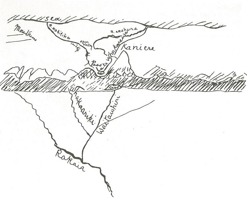
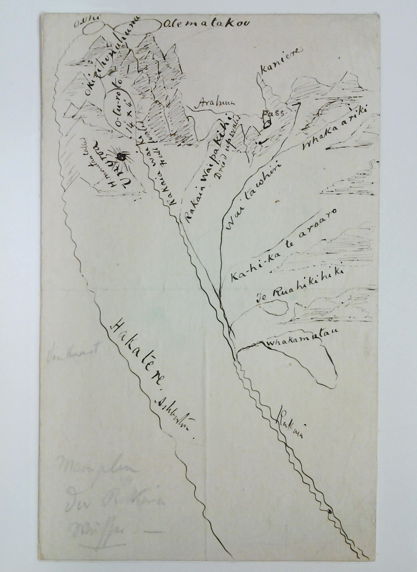
The revelation of the pass at the head of the Rakaia River is traditionally accorded to the arrival on the east coast of a Kāti Wairaki woman named Raureka. Born at the old settlement of Lake Kaniere, Raureka found her way across Kā Tiritiri-o-Te-Moana (the Southern Alps) carrying with her a pounamu toki (adze). On arrival in the Arowhenua region she was met and cared for by a party of Kāi Tūhaitara to whom she demonstrated the superiority of her stone tool. More importantly she revealed the route she had taken and provoked further exploration of the foothills and the route itself.

It was the knowledge of the route that was of first importance. Tūhaitara knew of the pounamu and its superiority. What they wanted to know was how to get to it. The detailed explanation of the route by Raureka is the key traditional event which led to the further exploration and later utilisation of the region not simply as a trade route but as a major resource zone in its own right.

The story of Raureka and the discovery of pounamu was depicted in South Canterbury Saga, a film made by Folio Films in 1952 to commemorate the Timaru Centennial. The film features Ngāi Tahu whānau members as the cast and was filmed on the banks of the Ōpihi River.

Dawn Of Recorded Maori History

View video

Information provided by Tarawhata to Edward Shortland

In 1843-44 Edward Shortland held the title of Protector for the Aborigines. During his census of the southern Māori population of New Zealand he travelled from Waikouaiti to Akaroa. Shortland was initially unable to cross the Waitaki River, staying with the southern Ngāi Tahu rangatira Te Huruhuru at Te Puna-a-Maru on the southern bank of the Waitaki.

Shortland eventually managed to cross the Waitaki where he was guided by Te Huruhuru along the old Māori travel route to Waihao. From there, Shortland continued travelling north along the coastline reaching the Kāti Huirapa pā of Te Waiateruati, near the Ōpihi River.

At Te Waiateruati Shortland was hosted by the Kāti Huirapa chief Te Rehe. Tarawhata, a son of Te Rehe, accompanied Shortland for the remainder of his journey north. During the journey Tarawhata explained to Shortland that the Rakaia River was sourced from nine bodies of water, with the northernmost one being Ōkapohia near Arahura. The expression that Tarawhata used was “ki te ritenga mai o Arahura”, which literally means “opposite the Arahura”. Tarawhata named the sources of the Rakaia as Okapohia, Onakariki, Te Waitāwhiri (Wilberforce River), Pōhatukoko, Kareaonui, Rakaia-wai-pākihi (Mathias River), Rakaia-wai-ki (southern branch of the Rakaia River), Ōtūroto (Lake Heron) and Maimai.

<p>This is a section of the map of Te Waipounamu drawn by Edward Shortland. The map shows that the Orakaia has its source in nine lakes. This information was provided by Tarawhata when he guided Shortland from Te Waiateruati north.&nbsp;Shortland, E. (1974) The southern districts of New Zealand: a journal, with passing notices of the customs of the aborigines. Christchurch, N.Z.: Capper Press. (Original work published 1851)</p>

Gallery 1

View gallery

Noti Raureka by a Kāi Tahu kaumātua, 1865


This map showing the traditional travel route over Noti Raureka (Browning Pass) was drawn by an unidentified Kāi Tahu informant for Revd James West Stack in 1865. The Provincial Government had asked Stack to seek information from Kāi Tahu kaumātua (elders) about traditional travel routes through Kā Tiritiri-o-te-moana (the Southern Alps) in the hope that this might assist with determining the best route for a road to link Canterbury with the newly discovered goldfields on Te Tai Poutini (the West Coast).

Although Stack spoke with several Kāi Tahu people who had travelled to Whakamatau (Lake Coleridge), he only found one kaumātua who had travelled over Noti Raureka. The old man explained that the pass was reached by travelling up the Waitāwhiri (Wilberforce River). He also said that knowledge of the route had become tapu (restricted) after a travelling party died on the pass in heavy snow. Stack sent the map to the Canterbury Provincial Government on 31 March 1865, and it was immediately dispatched to surveying parties in the field. Surveyors Browning and Griffiths successfully traced the route described on the map, and Browning’s name was given to the pass.

The map shows a large mountain and lake at the top of the pass, and a cave where Kāi Tahu parties camped overnight. Although Arthurs Pass became the principal travel route between Canterbury and Te Tai Poutini, a track was also formed over Noti Raureka that was extensively used. The location of the original map is unknown, but it was photographed by the ethnographer William Taylor around 1942.

This map showing the traditional travel route over Noti Raureka (Browning Pass) was drawn by an unidentified Kāi Tahu informant for Revd James West Stack in 1865. William Anderson Taylor Collection, Canterbury Museum, 1968.213.2433

Map of Māori Place Names in the Rakaia Catchment


This map of Māori place names in the Rakaia and Hakatere (Ashburton River) catchments was probably drawn by a Kāi Tahu informant for Julius von Haast around 1865. As the geologist for the Canterbury Provincial Government in the 1860s, Haast was exploring and surveying the major Canterbury River systems that drain the eastern flanks of Kā Tiritiri-o-te-moana (the Southern Alps).

The map provides the earliest comprehensive description of the Rakaia and Hakatere rivers. It includes detailed information on the topography of the river systems, lakes and passes of both catchments. Place names on the map include Ōtūroto (Lake Heron), Whakamatau (Lake Coleridge), Te Ruahikihiki (Lake Selfe), and Ōkirihonuhonu (Lake Emma). It also shows that the Rakaia is divided into several sections: Rakaia-wai-kī is the southern branch of the Rakaia, Waitāwhiri is the Wilberforce River, and Rakaia-wai-pākihi is the Mathias River. The name ‘Rakaia’ specifically refers to the section of the river from its mouth to the junction of the Wilberforce and Mathias rivers.

Although the identity of the Kāi Tahu informant is unknown, the place names are consistent with other reliable sources of tribal information. Haast may have obtained the map directly from a Kāi Tahu person or via his friend Revd James West Stack who lived with Kāi Tahu at Tuahiwi. Its style and content resemble the Noti Raureka map, raising the possibility that both were drawn by the same person.

Maoriplan der Rakaia Wasser, Johann Franz Julius von Haast, MapColl-q834.44cdc, Alexander Turnbull Library